Log in
All resources
Create a design
337 Free Artworks of Maps Of Lakes
bibliothèque nationale de france
peru. incidents of travel and exploration in the land of the incas
lake titicaca
university of washington
maps of agnano and grotta del cane by braun & hogenberg
lake parime
context files from gallica
utagawa school,kasei culture,ukiyo-e
utagawa hiroshige
nicolas sanson. “mappe-monde, ou carte generale du monde.”
atlas sive cosmographicae (gerardus mercator, 4th edition 1613)
maps of lake geneva by jacques goulart
physical geography (1899) by davis
maps of crater lake
maps of mexico by mercator-hondius
cartography
maps
french-language maps
daniel de la feuille
peru. incidents of travel and exploration in the land of the incas
lake titicaca
mappe-monde geo-hydrographique (sanson and jaillot, 1674)
a class-book of modern geography (1898)
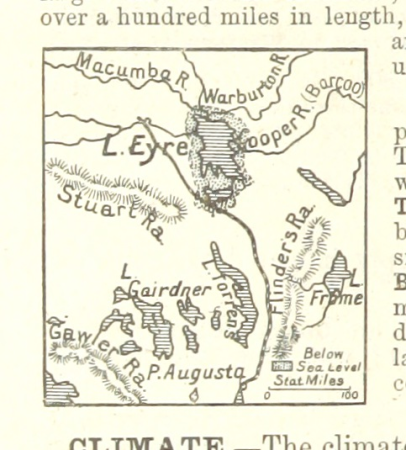
lake eyre
cornell's primary geography (1860)
old maps of lake geneva
maps of agnano and grotta del cane by braun & hogenberg
bibliothèque nationale de france
nouvelle géographie universelle, vol. x
lake manzala
peru. incidents of travel and exploration in the land of the incas
lake umayo
peru. incidents of travel and exploration in the land of the incas
lake titicaca
peru. incidents of travel and exploration in the land of the incas
lake titicaca
peru. incidents of travel and exploration in the land of the incas
lake titicaca
maps from the earth and its inhabitants, vol. v
velikiy novgorod
maps in the library of congress
1852 maps
a walloon family in america - lockwood de forest and his forbears (1914)
orientalism
maps of agnano and grotta del cane by braun & hogenberg
context files from gallica
maps of agnano and grotta del cane by braun & hogenberg
context files from gallica
picturesque america; or, the land we live in (1872)
1872 maps
the fifty-three stations of the tōkaidō (hoeidō edition, metropolitan museum of art)
utagawa school,kasei culture,ukiyo-e
westmorland, cumberland, durham, and northumberland (1858)
old maps of westmorland
voyages and travels to india, ceylon, the red sea, abyssinia, and egypt, vol. 3
henry cooper (engraver)
utagawa school,kasei culture,ukiyo-e
ndl-dc 1307523 tōkaidō 53 tsugi
birds-eye view of seattle, 1884
ships in puget sound
pencil drawings in the rijksmuseum amsterdam
schetsboek met 60 bladen, van reijer stolk
atlas, ou représentation du monde universel et des parties d'icelui, faicte en tables et descriptions très amples et exactes, divisé en deux tomes. édition nouvelle... - btv1b53103889w
17th-century maps of guyana
through the heart of patagonia (1902)
general carrera lake
nicolas sanson. “mappe-monde, ou carte generale du monde.”
map of the bosphorus strait by guillaume sanson (1665)
nicolas sanson. “mappe-monde, ou carte generale du monde.”
1667 map of madagascar by guillaume sanson
carte de moscovie by guillaume de l'isle (1706)
university of washington
carte de barbarie, nigritie, guinée par guillaume delisle (1707)
university of washington
chicago and the midwest, newberry library
fort winnebago, wisconsin
topographia helvetiae, rhaetiae et valesiae (1654) engravings
historical images of vevey
carte de l'afrique françoise par guillaume delisle (1726)
philippe buache
sigismund's map of moscow
301 - 337 of 337
/ 4